Landforms of Erosion
Landforms of Erosion
This page develops several activities, including photograph analysis, animations, and diagrams to have students investigate wave action and the resulting landforms. Students look in detail at cliffs and wave-cut platforms, types of coasts of erosion, including concordant and discordant coasts, resulting headlands and bays and then wave refraction and stack formation. It uses several examples such as the Twelve Apostles, Australia, the Moher cliffs, Ireland and the Jurassic coast, England. There is a particular focus on sequencing including an in-depth photograph annotation assessment.
Enquiry Question
How do waves create coastal landforms of erosion?
Lesson Time: 1 Hour
Lesson Objectives:
- To describe and explain the characteristics of wave-cut platforms, cliffs, headlands and bays associated features
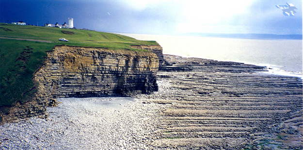
Starter Activity - Wave Cut Platforms - Processes
Study the following image and discuss how the cliff formed
Student Activity - Wave-cut platforms Map from Memory - Processes
Study the diagram for 30 seconds and then attempt to replicate it in your books. Alternatively, students can work in groups and they come up to see the image from the teacher's computer and then report back to their group who then based on the instruction of their team mate need to replicate the diagram. Repeat several times.
Once complete students should make a drawn sketch of their own
What factors are most important when explaining the formation of wave-cut platforms?
- Location
- Correct sequence
- Technical vocabulary
How can we incorporate:
- Location
- Sequence
- Vocabulary
Location - The backshore, intertidal zone, a named coastline featuring erosion landforms
Sequence - Begin with wave processes, wave types, erosion types, tide levels, wave-cut notch, overhang, collapse, retreat
Vocabulary - Destructive waves, hydraulic action, abrasion, wave-cut notch, intertidal zone, wave-cut platform, retreat
Student Activity - Headlands and Bays - Processes
Study the following photograph of the Cliffs of Moher in Ireland
- Describe the coastline and its characteristics
- Attempt to suggest reasons for it
Student Activity - Coasts of Erosion - Processes
Study the two images below and suggest reasons for the characteristics of the coastlines shown
Coastlines of erosion typically create a landscape of headlands and bays. These are the result of differentiated rates of erosion due to different levels of resistance in the geology. Concordant coastlines feature geology aligned parallel to the ocean. They typically have fewer landforms of erosion but in areas of weakness, the ocean might erode through one type of rock and then rapidly erode a weaker less resistant type of rock as shown in Lulworth Cove.
Discordant coasts have different rock types perpendicular to the ocean so differentiated rates of erosion occur creating headland and bays, that form low energy zones further inland.
Student Activity - Wave Refraction and Headland Erosion - Processes
Study the following animation sequence
Click the image and follow the slides - What causes wave refraction and how is it likely to affect the erosion of a headland
Watch the following video of the 12 Apostles in Australia, showing unique footage of before and after headland and stack collapse
Watch the following video of plasticine headland being eroded
Make your own video of a headland being eroded. Remember the basics of location, sequence and technical vocabulary
Student Assessment: Annotation exercise - Processes and Places
Study the following photograph and annotate it to explain all the processes and landforms present
The Twelve Apostles Assessment
Model Answer


